

The Fort l’Écluse or Fort de l’Écluse, formerly Fort de la Cluse is located in Léaz in the department of Ain (01), included in the Auvergne-Rhône-Alpes region created in 2015.
The Auvergne-Rhône-Alpes region is located between the Center and the South of France, it extends to the east on the borders of Switzerland with the Alps including Chamonix and Mont Blanc (the roof of Europe), Annecy and Val d’Isère and Provence to the south with the departments of Drôme and Ardèche. It also includes Auvergne and its volcanoes, a unique treasure in Europe, without forgetting Lyon, gastronomic capital and the Rhône Valley. This region which has 12 departments (Ain (01), Allier (03), Ardèche (07), Cantal (15), Drôme (26), Isère (38), Loire (42), Haute-Loire (43), Puy -de-Dôme (63), Rhône (69), Savoie (73) and Haute-Savoie (74)) is characterized by its tourist and sports activities, its regional and cultural specialties as well as the monuments and thermal spas.
Installed since the Mesolithic period, the Pas de la Cluse natural postern was a crossing point between the Jura and Alps massifs, connecting the plains of Lyon to the Lake Geneva basin in the time of Julius Caesar while fighting against the Helvetian invasions and promoting trade. In the Middle Ages, it became a motorable road where a toll was established. Following various wars between Savoyards, Bernese, Genevois and French, a castle was rebuilt between 1225 and 1277, in the footsteps of the Roman fortifications with the remains of the stronghold of the Sires of Gex which had given its name to the cluse. In 1601, the bailiwick of Gex was attached to the kingdom of France following the Treaty of Lyon, the stronghold was extended into a fortress and took the name of « Fort de la Cluse ». Destroyed by the Austrians in 1815, the Fort was rebuilt between 1821 and 1830.
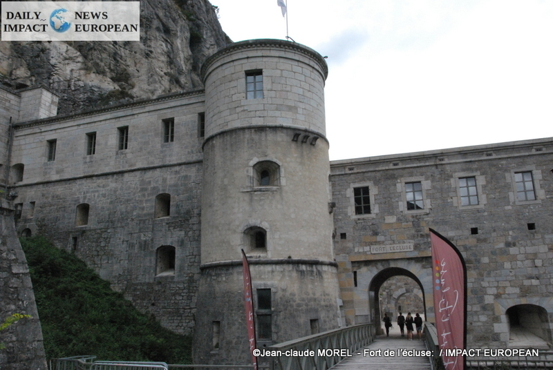
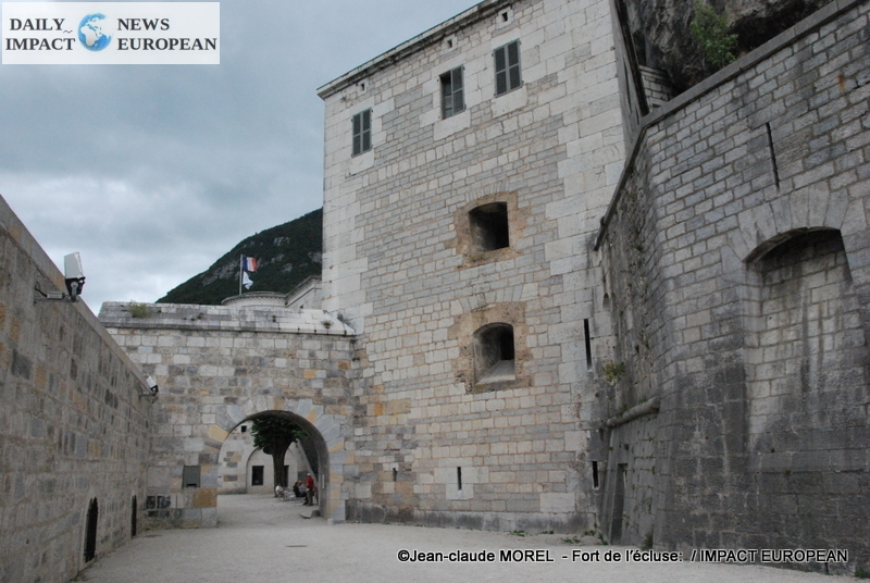
During the reconstruction, 2 of the 4 doors were removed and the « de France » and « Genève » doors were fitted with drawbridges equipped with « Bélidor » counterweight systems whose curved ramps are still visible. Several buildings for the garrison are established for the vertical protection, the interior partitioning and the scrolling of the locations of the guns all at embrasure. The Lower Fort becomes the archetype of a work « of prohibition » among the 4 or 5 copies existing in all the Hexagon.
In 1834, construction began on the Fort Supérieur, a fortified barracks 150m above the Fort to protect it from attacks from the mountain. The construction of this « Protection » work ends in 1848. Thanks to this construction, the projectiles launched from the top of the cliff will not reach the Lower Fort. A ditch is dug in the rock, facing the mountain, in front of the siege barracks on 2 levels, extended to the 2 wings by cannon casemates.
At the entrance, at the end of the long military road coming from Longeray, the gate dating from 1834, has more recent leaves and one of the last surviving drawbridge mechanisms « with constant counterweight and variable moment » invented in 1822 by the captain Derché.
At the front, a 20-meter-high staircase turret, placed against the counterscarp, leads to a group of casemates with reverse lights pulling on the glacis against the slope.
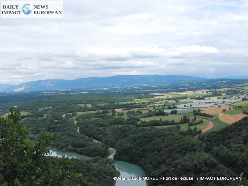
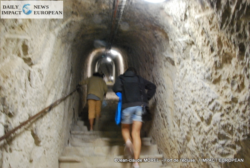
From then on, Fort l’Ecluse, built on the mountainside to control the gorge of the Lock, passage of the Rhône at the western exit of the Geneva basin in France, is made up of 2 forts linked by a long underground staircase of 1165 steps cut in la roche (only 830 are accessible to the public), included in a labyrinth of galleries where one meets an almost invisible artillery formed of stores, shelters and casemates for 14 pieces of cannon, doubled on the surface, by air battery positions free arranged in tiers or blending into the ground. This defense is oriented to defend the defile both upstream and downstream, the left bank of the Rhône and the dangerous slopes of Mont Vuache which became French in 1860, removing all strategic interest from Fort l’Ecluse which became a customs post on the road from Lyon to Geneva.
In 1939 a tunnel was drilled in the mountain to divert road traffic from the Fort’Ecluse. During World War II, the Fort, which is part of the Maginot Line, is the last stronghold to have resisted the Germans. After being decommissioned by the army in 1952, the Fort became in 1981 the priority of a SIVU and then of the Community of communes of the Pays de Gex; it has been open to the public every summer since 1995 for tours, exhibitions and events.
This construction reveals several centuries of military architecture (towers, watchtowers, loopholes, watchtowers, casemates, ammunition chambers), as well as the way of life of the 150 men who made up the garrison, the importance and the diversity of the system. defense and withdrawal of troops.
Due to its environmental quality, the gorge of the Lock on the Rhône is a protected site.The geographical position of the Fort de l’Ecluse, overlooking the Rhône, between Switzerland and France, near Bellegarde-sur-Valserine, allows organize discovery activities, trips with family or colleagues, supervised by qualified speakers, in complete safety whatever the workshop chosen among the 38 offered to the public:
- For the youngest: balance games, messy beams, tarzan jump, monkey bridges.
- For athletes: climbing crossings, 4 aerial zip lines, above a drop of 500 meters.
Located 30 minutes from Gex and Geneva, one hour from Lyon, Annecy, Chambéry, Bourg-en-Bresse, 1.5 hours from Chalon-sur-Saône and Mâcon. The Fort de l’Ecluse is located in the town of Léaz, route de Genève; it is accessible by the A40 motorway, exit n ° 10, Bellegarde-sur-Valserine.
To experience an adventure lasting more than 2 hours 30 minutes, go to the Lower Fort where the parking lot, ticket office and refreshment stand are located, then walk up to Upper Fort by the steps to discover a magnificent view of the Rhône.
Fort the Adventure Lock
Geneva route
01200 Léaz
Phone. +33 646 736 159
Views: 0
More Stories
Paris turns Bastille Day fireworks into a tribute to remembrance and resilience
France and South Africa strengthen strategic partnership in a changing global order
Paris Turns Into a Giant Fan Zone as France Chases World Cup Glory