
Surjoux’s « Pain de Sucre » waterfall is located in Ain. It is one of the curiosities of theRhône-Alpes region.
Auvergne-Rhône-Alpes region
The Auvergne-Rhône-Alpes region is located in the center-east of France. They bring together 12departments
• 4 in Auvergne: Allier (03), Cantal (15), and Haute-Loire (43) Puy-de-Dôme (63).
• 8 in Rhône-Alpes: (Ain (01), Ardèche (07), Drôme (26), Isère (38), Loire (42), Rhône(69), Savoie (73) and Haute-Savoie (74).
The most representative cities are Clermont-Ferrand, Vichy, Lyon, Annecy, Chamonix orGrenoble. From the Mer de Glace to the Volcanoes Park (Vulcano), via Notre-Dame deFourvière, Lake Annecy, or the Bastille in Grenoble, there is a lot to discover.
The region is also rich in places for hiking, whether in the mountains or in the forest. Awonderful time to discover the beauties of nature such as the waterfalls including that of Painde Sucre in the Ain department.
The department of Ain
The department of Ain is located in the northeast of the Auvergne-Rhône-Alpes region. Createdin 1790, the Ain bears the name of the river of the same name and is the first of the French departments. Heis surrounded by the departments of Jura, Saône-et-Loire, Rhône, the metropolis of Lyon,Isère, Savoy, Haute-Savoie. It has a common border with Switzerland. The cantonsGeneva and Vaud border on the northeast. There are 4 main regions (Bresse,Dombes, Bugey and Pays de Gex). There are also smaller ones (Val de Saône, Revermont,Coastal and the small regions of Bugey (Plateau de Retord, Valromey and Michaille).
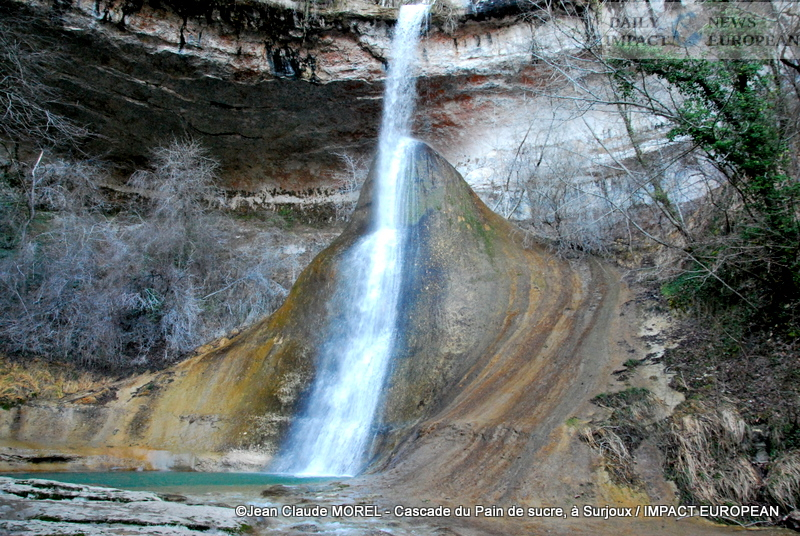
The Sugar Loaf waterfall
The Sugar Loaf waterfall « takes its name from the conical limestone concretion on whichthe water falls from the waterfall (Sugar Loaf).
Located in the Jura mountains, the Pain de Sucre waterfall is in the Surjoux forest,small town of the Bellegardien country in the department of Ain.
Upstream from Pain de Sucre and downstream from the bridge, the rock is carved out by water. You can seeappear on the ground a shape in the shape of a small spoon.
How to get there?
On the banks of the Rhône, an access path (no more than a hundred meters) goes up the Vézéronceto Sugar Loaf. To reach this island of greenery, we pass under the railway viaduct where wediscovers ruins. Before reaching the waterfall, we continue on limestone slabs. After oneabout fifteen minutes, you can discover a magnificent panorama. At the foot of the « Pain de Sucre », anatural pool of clear water, 5 to 6 meters deep.
The viaduct also has its history. Its construction began in 1856 but was stopped due tothe instability of a pillar. It was also destroyed by the maquis in 1944, then rebuilt after the war.
What is « Pain de Sucre »?
For millions of years, the waterfall has formed a gigantic stalagmite of tuff (porous rocklight, often crumbly, formed by lime deposits and produced in cold water). The « Bread of Sucre « is about twenty meters high and can be walked around. The point isrounded because the Vézéronce waterfall waters it before landing in the clear water basin of adepth of 6 meters.
The limestone was deposited gradually thanks to the rains which drained the soils of Valromey tothen bring these sediments back to the river. The bowl formed all around.
La Vézéronce
It has its source in the Colombier – Retord massif, in the town of Injoux-Génissiat, inplace called “Sous-Sac”. Fed by small streams and many springs, it flows throughpots and canyons, before jumping from the waterfall, to mingle with the waters of the Rhône, a fewhundreds of meters below.
In the 1980s, the implementation of a biotope decree prevented the degradation of theparticularly fragile geological formation of the waterfall. It regulated the practice ofcanyoning on the increase at the « Pain de Sucre » site.
To preserve the part upstream of the waterfall, the Vézéronce has received the « Wild River » label, atthe image of the Valserine, near Bellegrade. It was the first French watercourse to receive thislabeling. Since then, no human development has disturbed its course from the source to the waterfall.
What is the “Wild River” label
To protect rivers in Europe, WWF (World Wild Found) and ERN (European RiversNetwork) created in 2007, the “Wild Rivers” program. It helps them preserve thepollution, human activities or deterioration of the environment (…). There are 3 themes:
1) The « wild rivers site » label, launched in 2014. Tool at the service of environmental managersof running water, it improves the protection and conservation of rivers that present agood ecological operation. Preservation of ecosystems, exemplary management ofriver by local partners are its strengths. This French label (IFNOR) promotes the territory andthe willingness of stakeholders to protect this natural heritage. It is awaiting extension to the levelEuropean.
2) The network of « Wild Rivers » sites. It brings together all the labeled sites and is built overthe labels of the different territories. La Valserine, the first river in France to be labeled inOctober 2014 is the starting point. The network facilitates exchanges betweenmanagers, develop mutual aid between regions, and gradually make it possible torecognize the richness of these territories. To date, nearly fifty French riversare labeled.
3) The Wild Rivers Conservation Fund. Structure that works on a modelopen and participatory. It brings together private actors: individuals, companies, funds, foundations,patrons at the service of the project.
The history of Surjoux
Before becoming a tourist spot thanks to the waterfall, Surjoux was a hamlet of a fewhouses. The last port of the Rhône, it received boats loaded with salt, coming from theMediterranean, drawn on the towpaths. The return was made in the other direction, the holdsfull of quarry stones, used to build large cities.
Monument in Surjoux
In addition to the « Pain de Sucre » waterfall, Le Grenier à sel is a monument in Surjoux. It iscomposed of 2 guardhouse buildings as well as 2 entrance porches and a courtyard.
Because of the competition between France and Savoy, several lords built and shareda royal public building. The reception of cars coming from noon was supposed to generate foreign currency inflowsby passing trade.
The classic facade overlooks the Rhône and dominates a courtyard. The side guardhouses framedthe stables which lined the road at the bottom of the courtyard. One door to the south and another to the northallowed the passage of cars. The attic floor was to be reserved for housing. The ground floor Chaussée was used as a storage place with its 4 semi-circular vaulted stores. Until 1860, the place hadserved as a customs post then, to the employees in the navigation of the river. This attic is exemplary of18th century public buildings.

Cascade du Pain de sucre, à Surjoux 
Cascade du Pain de sucre, à Surjoux 
Cascade du Pain de sucre, à Surjoux 
Cascade du Pain de sucre, à Surjoux 
Cascade du Pain de sucre, à Surjoux 

Views: 0
More Stories
TIOMAN: The island that taught me to look beyond the sea
When the Sun Rises with the Sound of Engines: Inside Malaysia’s Mersing Culture Festival
Terengganu International Bike Week 2026 strengthened Malaysia’s position as a motorcycle tourism destination